History of
Plaistow

 |  |  |  |  |  |  |
|---|---|---|---|---|---|---|
 |  |  |  |
All images courtesy of Newham Archive
Plaistow has been part of the London
borough of Newham since 1965.
It is a largely residential area made
up of diverse communities.
Early History
Between the 1500s and the 1800s, West Ham was home to rich merchants and professionals who worked in the city. As a result, by the mid-18th and mid-19th centruies, Plaistow was the richest and largest village in the parish of West Ham. However, as time went on, Stratford's fortunes began to rise with a bridge over the river Lea that allowed easy access between Stratford and the rest of London. Plaisotw was cut off by the Thames marshes.

The Greengate pub, Barking Road, c.1900s
Leisure
The Greengate pub was first recorded in 1776 and in the 19th century it looked out over uninhabited marshland. It was rebuilt after the First World War and was eventualy closed in 2012. The site is now a Tesco Express.
The Green Gate Electric Theatre opened in 1911. In the 1920s it was known as the New Electric, then went back to being called The Green gate until 1953 when it became the Rio. It closed in 1957. The builidng became a snooker hall in the 1990s and was then taken over by Foursquare Gospel Church.

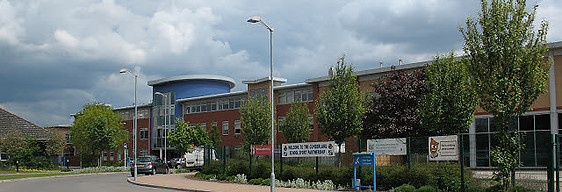
Newham University Hospital's main entrance on Northfield Close, 2010
Schools
New City Primary School opened on 4th October 1897 for all ages. It became a primary school in 1945 and until 1981 was organised into two separate departments, the infants and the juniors. In 1981 they were amalgamated under one head teacher.
Plaistow Municipal Secondary (Mixed) School was opened in 1926 on Prince Regent Lane to serve south Plaistow. When first built it could take 250 pupils and was extended in 1930 to take an additional 350 pupils. After the Second World War it was renamed Plaistow Grammar School. In 1972 it merged with Faraday Secondary Modern School to become Cumberland School and moved to Oban Close.
Cumberland School, 2010
Work
Plaistow has historically been an agricultural area and although it never became an area of heavy industry, residents went over the river to Silvertown for that kind of work, it has provided other occupations. Throughout the 1500s and 1600 there were silk weaving works which declined but thrived again from 1882 to 1943. Luke Howard had a pharmacutical factory in Plaistow from 1797 to 1805 and there was a small railway works on Plaistow Road from 1875 to 1934.
Plaistow was considered the heart of West Ham's printing tradition as the Plaistow Press took over the work of the Whitwell Press. In around 1928 the Plaistow press moved to a new building on the opposite side of Plaistow Road. A new building was built in New Plaistow Road when the Plaistow Road building was compulsary purchased by the borough council in 1955.
Hospitals
Plaistow Hospital opened in 1871 as a smallpox hospital. There was some evidence that the smallpox hospitals in the borough were helping to spread the disease, as by the end of the 19th century houses had been built around them. A new isolation hospital was built in Dagenham and Plaistow Hospital merged with another smallpox hospital. The site was enlarged and became a fever clinic; it was one of the most modern of its kind and pioneered the barrier method of nursing infectious patients. By the 1980s the hospital was for elderly long-stay patients. When the purpose built East Ham Care Centre was opened, Plaisotw Hospital was only ever half full or patients. It closed in 2006
Newham University Hospital opened on Glen Road in 1983 and provided centralised services for the residents of Newham.
Green Space
Plaistow Park, known as Balaam Street Recreational Ground until 1999, was opened in 1894 after the land was acquired by West Ham council. While it has lost its bandstand and other original features, the ornamental garden, fountain and the radial paths are still intact.
The Greenway was constructed ont he embankment of Joseph Bazalgette's Northern Outfall Sewer. It is a pedestrian/cycle highway that reaches Wick Lane in Old Ford (Bow) to the west and Royal Docks Road in Beckton to the east.
1 hr
70 US dollars2 hr
100 US dollars1 hr
70 US dollars1 hr
100 US dollars5 min
150 US dollars